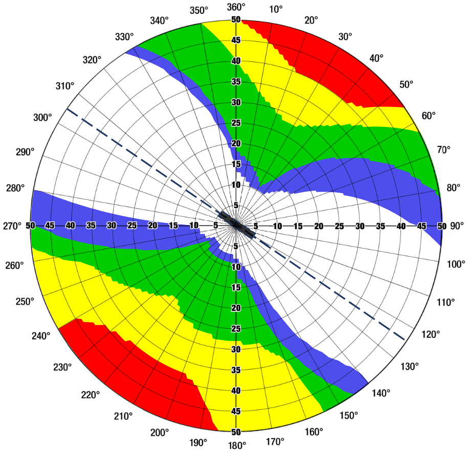
RUNWAY 30
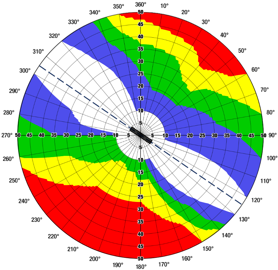
RUNWAY 12
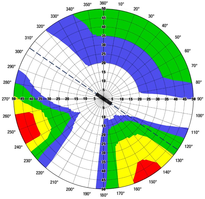
WATERFALL
This is the TWI system for EKVG Vagar Airport on the VATSIM network.
The TWI system uses data collected by the real-world operators of Vagar to predict the severity of turbulence on final approach. This software's dataset is based on the windroses published on the Danish AIP.
The TWI system predicts turbulent conditions individually for both departures and arrivals.
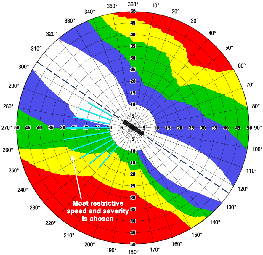
If the winds are gusting, the highest speed will be used. If the winds are variable, the system will display the worst case scenario. This is what they will follow in real life.
NONE: No substantial turbulence is predicted.
LIGHT: Light turbulence is predicted. There may be slight, erratic changes in attitude and/or altitude.
MEDIUM: Moderate turbulence is predicted. Variations in speed as well as altitude and attitude may occur but the aircraft remains in control all the time.
HEAVY: Moderate to severe turbulence is predicted. Large variations in speed as well as altitude and attitude may occur. The aircraft remains under control.
SEVERE: Severe turbulence is predicted. Take-off and landing in the indicated configuration is prohibited. There may be large, abrupt changes in attitude and altitude with large variations in airspeed. There may be brief periods where effective control of the aircraft is impossible. Loose objects may move around the cabin and damage to aircraft structures may occur.
NOTE: The TWI system is designed for Cat M aircraft (such as the A320 and B737). Light aircraft are particularly vulnerable in turbulent conditions.
Note: TWI closes runways for take-offs and landings separately. This means a runway could be closed for take-offs, but available for landings, or vice-versa.
This page will automatically refresh every 10 minutes. Every 2 hours, you will need to confirm you are still using the system.
Over 30 years, the operators of Vagar have collected data and pilot reports which have allowed them to create multiple 'windroses' (charts that show turbulence severity in relation to wind heading and speed). These are used to program the real-world TWI and are the basis of this system as well.
In real life, the TWI operates on a degree-by-degree basis, but this system uses 10 degree increments due to its use of METARs instead of direct access to a weather station. The real-world TWI also takes into account variations and gust frequency however, I do not have access to this data.
VFR flights, and IFR flights following an RNP AR procedure, can depart or arrive via a special route which takes them between two hills. These procedures have their own risks and windroses regarding turbulence so have their own TWI indicators.
If the winds at Skeid are variable, the system will calculate the severity for every 10-degree increment. For every 10 degrees away from the centre, the wind speed will be reduced by 2 knots (which is to handle simulator inaccuracies). The system will then use the highest severity result.
As an example, below is a calculation for the winds 26017G30KT 220V300. The system identifies the severity as HEAVY.
FOR SIMULATION USE ONLY
Provided and maintained by Ollie - 1553864
Discord: olli.ovh or #icelandic-chat